Contact Details
Kativik Regional Government (KRG)
P.O. Box 9
Kuujjuaq, Québec
CANADA J0M 1C0
- Phone: +1 819 964-2961
- Fax: +1 819 964-2956
- Email: cen@cen.ulaval.ca
STATION NAME AND OWNER
The CEN Clearwater Lake Research Station is legally owned by the Kativik Regional Government (KRG), but is operated by the Centre d’études Nordiques (CEN: Centre for Northern Studies) through a long term lease. This station is part of the CEN Network, more precisely the Qaujisarvik Network of stations and is part of a provincial park that is co-managed by KRG and the government of Québec (Tursujuq National Park).
LOCATION
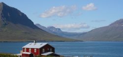
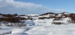
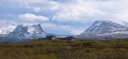
Situated in Nunavik on the shores of Clearwater Lake (Lac à l’ Eau Claire, 56°20’ N, 74°27’ W), the station is about 125 km inland from the eastern coast of Hudson Bay.
BIODIVERSITY AND NATURAL ENVIRONMENT
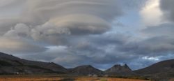
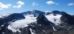
Clearwater Lake is the second largest natural lake of the province of Québec (2243 km2). It sits at an altitude of 240 m, the limit reached by the postglacial sea, and drains into Hudson Bay via Clearwater River (Rivière à l’ Eau-Claire) with a maximum outflow rate of 150 m3/s. The lake features two adjacent, circular basins (26 and 36 km in diameter) that were created by a meteoritic impact about 290 ± 20 million years ago (Permian Age). Even though vascular plant diversity is low on regional granite gneisses, the volcanic breccias (clastic-textured extrusive igneous rocks) situated on the islands of the western basin (11 islands forming a circle) are populated by 250 vascular species, 15% of which are specific to the shores. Avifauna is abundant and the islands constitute an enclave for shrub tundraA type of ecosystem in which tree growth is limited by low temperatures. The origin of the word is from from the Kildin Sami word t?ndâr, meaning "uplands" or "treeless mountain tract". In the northern... More in an area that is rather characterised by forest tundraA type of ecosystem in which tree growth is limited by low temperatures. The origin of the word is from from the Kildin Sami word t?ndâr, meaning "uplands" or "treeless mountain tract". In the northern... More.
HISTORY AND FACILITIES
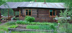
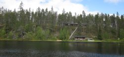
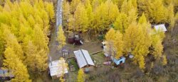
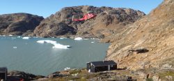
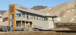
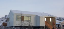
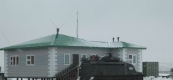
CEN research has been conducted here since 1980, but the station buildings are recent, built in 2000 and upgraded in 2011. The buildings were originally built by outfitters but have been considerably upgraded by the CEN. The three buildings can accommodate nine people. They are equipped with solar-powered electricity, running water, dry toilettes, and oil heating. The station is accessible from June to October by float plane or helicopter. About 10 km to the southeast, there is a natural airstrip maintained by Air Inuit. However, a river separates the station from the airstrip.
GENERAL RESEARCH AND DATABASES
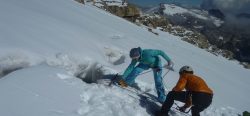
Past research has focused on regional ecosystemAll the living organisms (including people) in an area as well as its physical environment, functioning together as a unit. An ecosystem is made up of plants, animals, microorganisms, soil,... More dynamics, specifically on the response of the forest to disturbances such as fire and insect outbreaks, dendrochronologyThe practice of working out the age of wooden structures by studying and counting tree rings. When a tree grows, it puts on new growth under the bark. If the... More, riparian vegetation and biodiversityBiological diversity. The many and varied forms of life on Earth (collectively known as biota). As well as diversity of species (species diversity), there is also diversity within populations of a... More, periglacial processes, secular variations in water levels, and hydrologyThe study of water in the environment, particularly its amount, movement and quality. It encompasses water in rivers, lakes, glaciers, soil and underground aquifers. The way in which water (liquid and... More. Other research topics have covered limnology of the two basins, geological and geomorphological history, and biophysical features of the area. Wildlife studies (birds, caribou, small mammals, fish, and biting insects) have also been conducted, as well as archeological studies (recently). CEN operates three climateThe average weather we would expect over a long period of time (seasons, years, decades). Climate varies from place-to-place across the Earth. Climate is determined by long-term (over at least... More stations in and around the western basin of the lake, one of which is on a small island directly in the centre of the basin. In addition to scientific literature, CEN has extensive climateThe average weather we would expect over a long period of time (seasons, years, decades). Climate varies from place-to-place across the Earth. Climate is determined by long-term (over at least... More data since 1986 which is available at: www.cen.ulaval.ca/nordicanad or upon request (cen@cen.ulaval.ca)
HUMAN DIMENSION
Clearwater Lake is situated within the boundaries of a provincial park and on aboriginal land. First Nations people, the Cree, still use the land extensively for hunting and fishing, especially during spring and autumn. There are no permanent settlements around the station, the closest village Umiujaq is about 135 km west on the shores of Hudson Bay. Access to the station is organised by CEN from the Whapmagoostui-Kuujjuarapik Research Station.
ACCESS
Clearwater Lake is an isolated station in a provincial park; therefore all research activities must be proposed and planned in advance. Contact CEN for more information (cen@cen.ulaval.ca).