Contact Details
Geocenter Denmark
University of Copenhagen
DK 1350 Copenhagen K
Denmark
- Phone: (+45) 35 32 25 00
STATION NAME AND OWNER
The Sermilik Station is owned by the Department of Geosciences and Natural Resource Management, Geocenter, Denmark, University of Copenhagen.
LOCATION
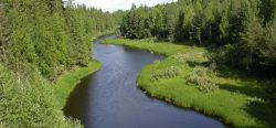
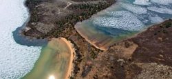
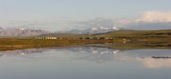
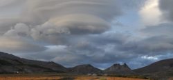
The station is located at 65°40’ N and 38°10’ W in southeast Greenland, about 20 km north of the small town Tasiilaq (Ammassalik). The station is situated on the shore of the Sermilik Fjord on the west side of Ammassalik Island adjacent to the Mittivakkat GlacierA glacier is a large, persistent body of land-based ice that forms over many years where the accumulation of snow is greater than its loss (ablation). The ice in a... More, a local small ice cap.
BIODIVERSITY AND NATURAL ENVIRONMENT
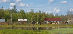
The research area is situated in the low arcticDefinitions of the Arctic vary according to environmental, geographical, political, cultural and scientific perspectives. Some scientists define the Arctic as areas having a high latitude, long winters, short, cool summers,... More coastal vegetation zone, and demonstrates a large floraThe plants that live in a particular region, habitat or time (such as geological period like the jurassic). For animals, we use the term fauna, and to collectively refer to all... More diversity. It is dominated by dwarf-shrub heaths, snow-bed communities, and open fell-field communities. Fens, herb slopes, and copses are present but are only found in smaller niches in the alpine dominated landscape.
HISTORY AND FACILITIES
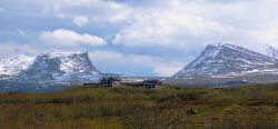
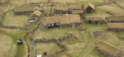
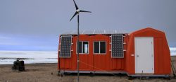
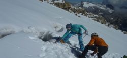
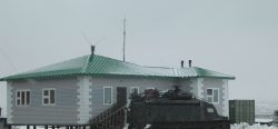
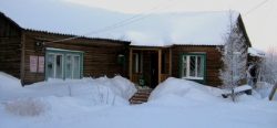
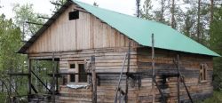
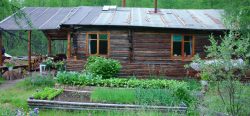
During an expedition in 1933, led by the famous polar researcher Knud Rasmussen, the first surveys of glaciers and geomorphology were carried out on Ammassalik Island and at the Mittivakkat GlacierA glacier is a large, persistent body of land-based ice that forms over many years where the accumulation of snow is greater than its loss (ablation). The ice in a... More. In 1970 a permanent field station, the Sermilik Research Station, was established, to provide a logistic base for the on-going glaciological, hydrological, and geomorphological investigations of the Mittivakkat GlacierA glacier is a large, persistent body of land-based ice that forms over many years where the accumulation of snow is greater than its loss (ablation). The ice in a... More and its catchment. In 1993, an automatic meteorological station was established at a nunatak situated close to the equilibrium line of the Mittivakkat GlacierA glacier is a large, persistent body of land-based ice that forms over many years where the accumulation of snow is greater than its loss (ablation). The ice in a... More to study the glacierA glacier is a large, persistent body of land-based ice that forms over many years where the accumulation of snow is greater than its loss (ablation). The ice in a... More climateThe average weather we would expect over a long period of time (seasons, years, decades). Climate varies from place-to-place across the Earth. Climate is determined by long-term (over at least... More (515 m a.s.l.). In 1997, a second meteorological station was established, to study the climateThe average weather we would expect over a long period of time (seasons, years, decades). Climate varies from place-to-place across the Earth. Climate is determined by long-term (over at least... More in the coastal region. A third meteorological station was established at about 200 m a.s.l. in 2009, comprising data on short wave incoming radiation, temperature, relative humidity, wind (direction and speed), and precipitation. The main building of the station is an insulated wooden house of 60 m2 with three rooms for scientists, a dining room, a living room, a kitchen, a toilet, and a storage room. A second, non-insulated building of 50 m2 holds workshop, equipment, generator, a rubber boat, as well as optional accommodation for four persons in a separate room. The station buildings allow for accommodation of 6-10 researchers. During student summer field courses a tent camp is established at the station.
GENERAL RESEARCH AND DATABASES
The station supports a comprehensive year-round monitoring program covering basic climatology and local climateThe average weather we would expect over a long period of time (seasons, years, decades). Climate varies from place-to-place across the Earth. Climate is determined by long-term (over at least... More gradients in the Mittivakkat GlacierA glacier is a large, persistent body of land-based ice that forms over many years where the accumulation of snow is greater than its loss (ablation). The ice in a... More drainage basin, glacierA glacier is a large, persistent body of land-based ice that forms over many years where the accumulation of snow is greater than its loss (ablation). The ice in a... More mass balanceThe difference between the amount of ice a glacier gains in winter and the amount lost in summer. A glacier which is gaining mass has a positive mass balance: more ice is... More, run-off and sediment transport, and the development of coastal and delta geomorphology. Data are available on request from the three climateThe average weather we would expect over a long period of time (seasons, years, decades). Climate varies from place-to-place across the Earth. Climate is determined by long-term (over at least... More stations and a hydro metric station. GlacierA glacier is a large, persistent body of land-based ice that forms over many years where the accumulation of snow is greater than its loss (ablation). The ice in a... More mass-balance measurements and glacierA glacier is a large, persistent body of land-based ice that forms over many years where the accumulation of snow is greater than its loss (ablation). The ice in a... More surveys has been carried out since the mid 1980s and delta surveys since 1989. Maps, digital 3D terrain models, satellite data, and aerial photographs, in addition to a complete bibliography of publications arising from research at the Sermilik Research Station are available on request.
HUMAN DIMENSION
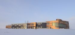
More than half of the population of East Greenland (c. 3000 inhabitants) live in the town Tasiilaq (c. 1700 inhabitants) which is located 20 km south of the research station. Even though the traditional Inuit culture still plays a major role in daily life, Tasiilaq is also a modern community. Fishing, hunting, service industries, and tourism are the major businesses in the town. The Ammassalik Island and the valleys behind the town have a unique floraThe plants that live in a particular region, habitat or time (such as geological period like the jurassic). For animals, we use the term fauna, and to collectively refer to all... More and are popular places for hiking.
ACCESS
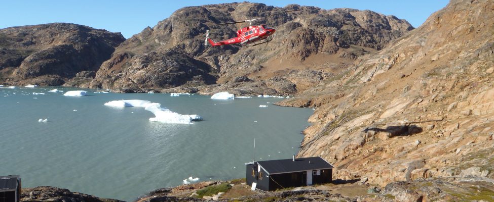
The Sermilik Research station can be reached by commercial air carrier via Island to Kulusuk Airport (Greenland Air or charter flights) followed by a helicopter flight to Tasiilaq. From Tasiilaq to the station a boat or a helicopter charter is recommended depending on the weather, snow or ice conditions, and the amount of luggage/cargo. It is also possible to reach the station after a 15-20 km hike. It is highly recommended to book favorable air tickets half a year in advance and to plan at least two travel days to reach Sermilik Station from Europe.