Contact Details
Directeur
Centre d'études nordiques
Professeur titulaire
Département de géologie et de génie géologique
Université Laval
Québec (Québec)
Canada
G1V 0A6
Poste: 402746 (GLG-GGL)
- Phone: +1 (418) 656-2746
- Email: cen@cen.ulaval.ca
STATION NAME AND OWNER
CEN Salluit Research Station is owned and run by Centre d’études Nordiques (CEN: Centre for Northern Studies) whose secretariat is based at Université Laval, Québec, Canada.
LOCATION
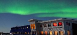
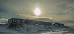
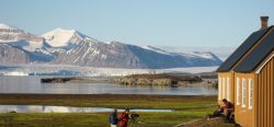
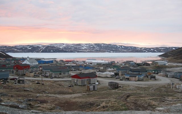
The station is situated in the Inuit community of Salluit, Nunavik, Québec, Canada (62°12’ N, 75°38’ W).
BIODIVERSITY AND NATURAL ENVIRONMENT
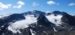
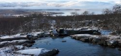
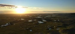
Salluit is located in the low arcticDefinitions of the Arctic vary according to environmental, geographical, political, cultural and scientific perspectives. Some scientists define the Arctic as areas having a high latitude, long winters, short, cool summers,... More tundraA type of ecosystem in which tree growth is limited by low temperatures. The origin of the word is from from the Kildin Sami word t?ndâr, meaning "uplands" or "treeless mountain tract". In the northern... More in the continuous permafrostPermafrost is frozen ground that remains at or below zero degrees Celsius (32 degrees Fahrenheit) for two or more years. It forms in regions where the mean annual temperature is... More zone. The hilly bedrock consists principally of gneissic rocks from the Precambrian belonging to the Canadian Shield. The village is located in a valley that opens to the shore of Sugluk inlet (a fjord). The surrounding landscape consists of rocky plateaus with a hilly topography. The region was deglaciated about 8000 years ago and sectors below the elevation of 150 m were inundated by the post-glacial d’Iberville Sea. Till and some glacio-fluvial sediments are the major surficial materials on the plateaus, while the Salluit valley and the other valleys that connect with the fjord (particularly at the fjord head) are floored with fluvial sediments in terraces and marine clay. The geologyThe study of the solid Earth, rocks and processes by which rocks form. 'Geo' is derived from the Greek word for Earth.... More and the oceanography of the fjord are poorly studied. The fjord opens to Hudson Strait. Mean annual air temperature is c. -8 °C and annual precipitation c. 300 mm (50 % snow).
HISTORY AND FACILITIES
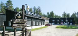
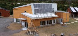
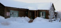
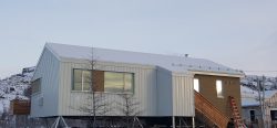
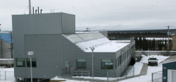
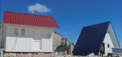
Research has been conducted in the region in both natural and human sciences since the early 1960s by various groups. PermafrostPermafrost is frozen ground that remains at or below zero degrees Celsius (32 degrees Fahrenheit) for two or more years. It forms in regions where the mean annual temperature is... More research by the CEN began in 1987. In the context of Climate ChangeAccording to the United Nations Framework Convention on Climate Change, climate change is change in the climate of the whole Earth or a region of the Earth that is believed... More, a major research program was undertaken in 2002 to support community adaptationIn ecology, adaptation is the process by which a species acquires certain traits that improve survival in a particular environment.... More to changing permafrostPermafrost is frozen ground that remains at or below zero degrees Celsius (32 degrees Fahrenheit) for two or more years. It forms in regions where the mean annual temperature is... More and to assist the community in addressing housing and infrastructure needs for the rapidly growing population. The field station (a house) was built in 2010 thanks to a grant acquired from a federal research infrastructure program.
GENERAL RESEARCH AND DATABASES
Numerous theses and research papers have been published on permafrostPermafrost is frozen ground that remains at or below zero degrees Celsius (32 degrees Fahrenheit) for two or more years. It forms in regions where the mean annual temperature is... More, periglacial geomorphology (ice-wedges, slope processes), archaeologyThe study of past human activity, mainly through studying artefacts and structures left behind, and by revealing other evidence of past activities. The first systematic archaeological excavations in the Arctic... More, climatology, paleo-climate (paleo-soils and lake cores), population, culture and land management in the area. ClimateThe average weather we would expect over a long period of time (seasons, years, decades). Climate varies from place-to-place across the Earth. Climate is determined by long-term (over at least... More and permafrostPermafrost is frozen ground that remains at or below zero degrees Celsius (32 degrees Fahrenheit) for two or more years. It forms in regions where the mean annual temperature is... More temperature data from automatic stations, in operation since August 2002, which are available at: www.cen.ulaval.ca/nordicanad or upon request (cen@cen.ulaval.ca). Surficial geologyThe study of the solid Earth, rocks and processes by which rocks form. 'Geo' is derived from the Greek word for Earth.... More and permafrostPermafrost is frozen ground that remains at or below zero degrees Celsius (32 degrees Fahrenheit) for two or more years. It forms in regions where the mean annual temperature is... More maps have also been produced for the territory.
HUMAN DIMENSION
Inuit and their ancestors have occupied the region for over 3500 years. Many of the key archaeological sites of the Hudson Strait region are along the fjord coastline and along Hudson Strait. The shift from a nomadic lifestyle to permanent settlement led to the growth of the village in the 1930s with the installation of the Hudson Bay Company and churches. The population size has reached about 1350 inhabitants, with youths constituting an important part of the population.
ACCESS
Access is by commercial airlines from Montréal and Québec city. Every summer, several cargo ships allow shipping of heavy equipment and materials, though this requires planning in advance. The station has no permanent staff. Local support for services and field work is available in the community. Station users are instructed to do their cleaning and take good care of the premises and do minimal maintenance, if needed. Contact CEN (cen@cen.ulaval.ca) for more information.